A note on this fact-check: the most significant problem with this page wasn’t inaccuracy, it was a structural publishing defect - a large block of text had been duplicated and pasted into the wrong place, breaking a sentence in half, and several internal editorial placeholder comments were never removed before the page went live. Both are fixed below. The dense run of 17th-19th century dates and names throughout has not been independently re-verified line by line - see the note above.
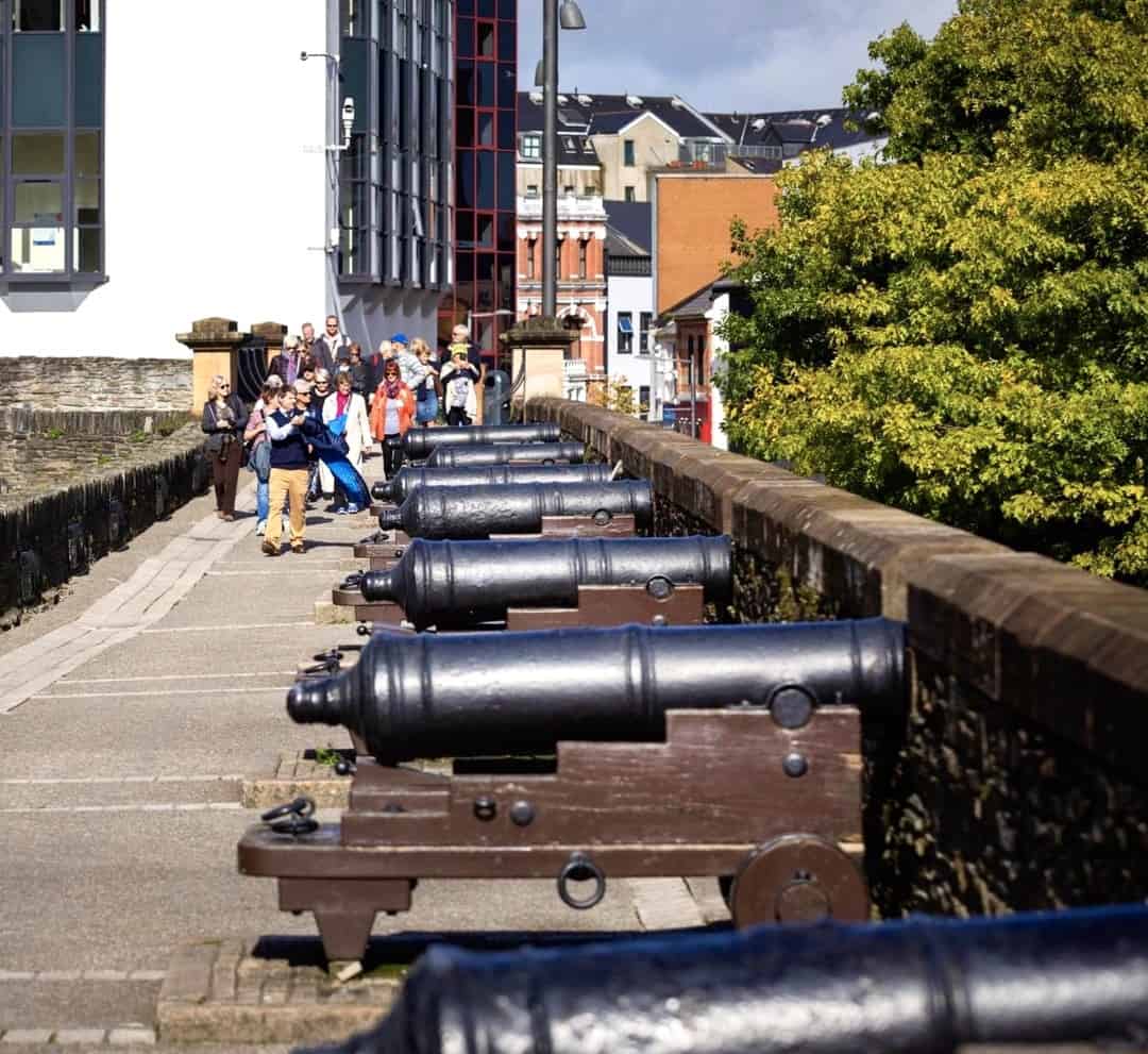
Nestled in the northwest corner of Northern Ireland, Derry - or Londonderry, depending on whom you ask - stands as a city with a pulse that beats in rhythm with its storied past. Towering above its modern streets and historical landmarks are the ancient walls, witnesses to centuries of siege, conflict, and resilience.
Walled Cities
By the end of the 17th century, Ireland had over 40 fortified towns and cities - a handful in Ulster. When the Walls of Derry were built between 1613 and 1619, they proved the most formidable and enduring in the province. Similar fortifications survive elsewhere in these islands - Chester’s Roman walls, York’s Norman ones - but Derry is the only city in Ireland to have preserved its walls in their entirety, partly because they’re comparatively young (under 400 years old), but mainly because generations of citizens and organisations made sure they were preserved.
Derry’s First Defences
In 1162, Flathbert O’Brolchain, a successor to St Columba, and Muirchertach O’Loughlin, an Irish chieftain, removed over 80 dwellings to build an earth wall (a cashel) around St Columba’s abbey in Derry - one of the earliest recorded defensive fortifications in Ulster.
The English had wanted to fortify Derry since the reign of Queen Mary (1553-1558), finally doing so in September 1566 under Colonel Edward Randolph, who expelled the town’s Irish inhabitants and built earthworks for a garrison. Randolph died months later, killed in a clash with Shane O’Neill, Earl of Tyrone. In April 1567, an accidental fire in the garrison’s gunpowder magazine (housed in the town’s first cathedral, the Teampall Mór, built 1164) caused an explosion that destroyed the cathedral and soldiers’ quarters - the English sailed home, leaving Derry in ruins for years.
In 1600, the English returned. Sir Henry Docwra was sent by Lord Deputy Mountjoy to occupy and fortify the town with a large force of men, tasked with keeping the Ulster chieftains in check. Landing at Culmore on 16 May, he marched to Derry days later, describing his first view of the town:
“A place in manner of an island comprehending within it 40 acres of ground, wherein were the ruins of an Abbay, of a Bishopp’s house, of two churches, and at one of the ends of it an old castle, the river called Loughfoyle encompassing it all on one side, and a bogg most cornonlie wet…”
Old Derry was rightly likened to an island - the River Foyle had once divided around the town’s central hill, though by 1600 the western branch had largely disappeared into marsh. Docwra’s men built two more forts using scavenged materials: a lower one at the river’s edge for stores, and an upper one on high ground for soldiers’ quarters. King James I granted Derry its first Charter of Incorporation in 1604.
Docwra left in 1606, replaced by the widely disliked Sir George Paulett, whose mismanagement and arrogance alienated Cahir O’Doherty, Chieftain of Inishowen. O’Doherty used inside knowledge of the fortifications to attack in April 1608, killing Paulett and taking the city after two days’ fighting - Derry’s defences had fallen a second time, this time to an enemy. Captain John Vaughan’s forces recovered the city shortly after and rebuilt it; Lord Deputy Chichester fined O’Doherty’s followers in Inishowen to cover the repairs.
Chichester, recognising that earthwork defences gave little real protection, urged the Privy Council to have the city “walled in stone” - the only real safeguard against another O’Doherty-style disaster - and petitioned the king in 1608 to carry out the plan.
The Plantation Begins
In 1609, the Earl of Salisbury proposed establishing a Protestant colony on the annexed lands of the O’Neills and O’Dohertys, inviting London’s merchant guilds to undertake the Plantation of Derry. Guild representatives sent to assess the area returned a favourable report - after the Privy Council quietly instructed Chichester to show them only the area’s good points. Articles of Agreement, drawn up in January 1610, required fortifications completed by 1 November 1611. In 1611, Lord Carew surveyed the Ulster Plantation; a plan known as “The Platt of the Derrie 1611,” commissioned as part of that survey, projected the city walled on three sides only, covering a larger area than the walls eventually built. Delays over land surrender meant almost nothing was built by the deadline, and Carew’s planned walls were never constructed.
On 29 March 1613, the Honourable The Irish Society was formally incorporated by Royal Charter to carry out the Plantation, and the city was renamed Londonderry for its new London connection. In August 1613, Mathias Springham and George Smithes were sent to Derry to plan the walls, finding widespread corruption among city officials first. Their plan was approved by London’s Common Council in October 1613 (no record of it survives), and work on the walls finally began in May 1614.
Walls Constructed
Initial work - digging the ditch, raising the ramparts, quarrying stone - was slow. In September 1614, Peter Benson, a London master builder, was engaged to build the walls, paid partly in 1,000 acres of Donegal land. Sir Edward Doddington oversaw design and construction (later replaced by Captain John Baker), with Thomas Raven doing the surveying. Local labourers worked alongside London craftsmen - over 200 men in total, dividing their time between the walls and settlers’ houses. Local stone, slate, and rubble from ruined buildings were used, along with lime shipped in from London for strength.
By October 1615, the initial Plantation budget was spent, requiring a further £5,000 from the London Companies. A 1615 Irish uprising, quickly put down, spurred faster progress out of fear of further attack. Captain Nicholas Pynnar, Inspector of Fortifications, reported the walls complete by March 1619:
“The Citric of London Derry is now compassed about with a very strong wall, excellently made and neatly wrought… the circuit whereof is 284 Perches & 2/3 at 18 feet to the Perche… in every place of the wall it is 24-foot high and 6-foot thicke.”
The recorded cost of building the walls and other defences:
| Item | Cost |
|---|---|
| Walls and fortification | £8,357 |
| Digging the ditch and filling earth for ramparts | £1,500 |
| Levelling earth to lay ramparts | £500 |
| Gates, portcullises, and drawbridges | £400 |
| Total | £10,757 |
Bulwarks and Gates Named
In 1622, Sir Thomas Phillips and Richard Hadsor surveyed Derry, naming its bulwarks and gates for the first time: King James’s Bulwark, Prince Charles’s Bulwark, the Lord Deputy’s Bulwark, London Bulwark, Lord Docwra’s Bulwark, Lord Chichester’s Bulwark, the Governor of the Plantation’s Bulwark, and the Mayor of London Derrie’s Bulwark, alongside the Water Gate, Ferry Gate, and Bishop’s Gate (the future Butcher’s Gate wasn’t yet named). The survey also flagged real deficiencies - missing guardhouses, sentinel towers, and cannon platforms - and recommended a flooded defensive ditch through the bog, which was never built. Sir John Vaughan commanded 121 families and 110 armed men living within the walls at the time.
Little further work was done over the next five years amid a dispute between the Irish Society and the Crown over who should pay. A 1624 Royal Commission judged Derry vulnerable to attack; the Irish Society agreed to build guardhouses, platforms, and sentinel towers, but disputed responsibility for supplying cannon and ammunition, or digging the flooded ditch. Thomas Raven’s 1625 plan for an outer wall and ditch - which would have proved invaluable in 1689 - was never implemented amid the ongoing financial wrangling.
Early Siege Threats
In the 1641 Irish rebellion, Ulster’s Planters fled to Derry’s walls; the city was reinforced with arms and supplies from London but never actually attacked. In 1649, during the English Civil War, Derry was besieged for 20 weeks by forces loyal to Charles I - again, without any attempt to breach the walls, and the Royalists eventually retreated. Neither siege compared to what came in 1689: in both earlier cases, supplies kept reaching the garrison, and the walls themselves were never bombarded.
The Great Siege of 1689
The walls lay largely neglected for 40 years after 1649. The 19th-century historian Lord Macaulay, drawing on an inspection by French engineer Jean Thomas, described them at the time of the Great Siege as “contemptible” - a single overgrown wall, no ditch, rusty drawbridge chains, weak parapets - overlooked on almost every side by higher ground.
The siege’s roots lay in the 1688 removal of the Catholic King James II by the Protestant William of Orange. In Ireland, Jacobite forces loyal to James arrived at Derry’s Ferryquay Gate on 7 December 1688, led by the Earl of Antrim, to take command of the garrison. Fearing a massacre, thirteen apprentice boys rushed to shut the gates - the symbolic start of the Great Siege, still commemorated today (on 18 December, adjusted for the calendar change since).
Colonel Robert Lundy strengthened the walls with an outer defensive ravelin at Bishop’s Gate and outworks toward Windmill Hill. On the siege’s eve, buildings outside the walls on both sides of the Foyle were burned by the defenders to deny the besiegers cover. King James himself arrived at Bishop’s Gate on 18 April 1689, expecting an easy surrender; he was met with gunfire instead, marking the siege’s true start. He demanded surrender four times, was refused four times, and returned to Dublin, leaving his generals to besiege the walls for 105 days.
Cannon and mortar fire, concentrated between Bishop’s Gate and Butcher’s Gate, caused serious damage throughout. Defenders made running repairs with earth-filled barrels, reinforced the gates with timber and sods, and built a small improvised fort (Walker’s Fort, named for joint Governor Rev George Walker) outside the walls. Relief finally arrived on 28 July 1689. Contemporary explanations for the siege’s failure vary - Bishop William King later blamed besieger cowardice; James’s supporters pointed to a lack of cannon, mortars, scaling ladders, and battering rams.
During the siege, the bulwarks were informally renamed by the thousands of refugees sheltering within the walls, who didn’t know their original 1622 names:
| Siege name (Nevill’s report, 1689) | Original name (Phillips’s survey, 1622) |
|---|---|
| Church Bastion | King James’s Bulwark |
| Double Bastion | Prince Charles’s Bulwark |
| Ferry Bastion | Lord Deputy’s Bulwark |
| Newgate Bastion | London Bulwark |
| Royal Bastion | Lord Docwra’s Bulwark |
| Coward’s Bastion | Lord Chichester’s Bulwark |
| Water Bastion | Governor of the Plantation’s Bulwark |
| Gunner’s Bastion | Mayor of London Derrie’s Bulwark |
| Hangman’s Bastion | (unnamed) |
The bastions are still known by their siege names today.
Changes Since 1689
After the Great Siege, the Corporation repaired the damaged ramparts, walls, and gates, helped by £100 contributions from twelve leading London Companies. In 1702, with England at war with Spain and France, French engineer Captain Jean Thomas was appointed to inspect Derry’s defences; his 1705 report proposed flooding the low-lying ground beyond Bishop Street to create an “island fortress,” plus a citadel around St Columb’s College - none of it was ever built. The walls and gates were otherwise well maintained for the next 80 years, until the Corporation began altering their appearance from the late 18th century on, extensively rebuilding the original four gates. The version of the walls seen today largely dates from this period:
| Date | Alteration |
|---|---|
| 1789-90 | Bishop’s Gate levelled entirely; a Triumphal Arch, honouring King William III, erected in its place (its sculpted heads represent the Foyle, dated 1689, and the Boyne, dated 1690) |
| 1789 | Towers and guardhouses removed from Butcher’s Gate |
| 1789-95 | New Gate opened between London Street and Hawkin Street |
| 1791 | Guardhouse removed from over Shipquay Gate |
| 1795 | Ferryquay Gate widened and ornamented |
| 1800 | Bridge Act amendment allowed removal of walls/gates for the city’s benefit (used sparingly in practice) |
| 1803 | Castle Gate opened in the Parade |
| 1805-10 | Wooden gates removed from the Gates |
| 1810 | Butcher’s Gate entirely rebuilt and ornamented; Gunner’s Bastion removed |
| 1810-24 | Part of Hangman’s Bastion and all of Coward’s Bastion removed |
| 1826 | Governor Walker’s Pillar erected in Royal Bastion (demolished by a bomb in 1973) |
| 1837 | Steps built from Foyle Street onto East Wall through Water Bastion, most of which was removed over subsequent years |
| 1861 | Opening linking Orchard Street to Richmond Street - the only break in the walls’ circuit with no gate |
| 1865 | Magazine Gate erected, with sculpted heads of Captain Adam Murray and David Cairns, 1689 defence leaders; the section between Shipquay Gate and Magazine Gate heightened by 6 feet |
| 1866 | New Gate and Ferryquay Gate rebuilt; the latter’s keystones depict Rev George Walker and Rev James Gordon, 1689 defence leaders |
In 80 years, Derry’s walls changed from a working defensive fortification into an ornamented monument to those who defended the city two centuries earlier.
Secret Tunnels
Since the 1960s, tunnel-like structures found at various points within the walled city - East Wall, Shipquay Street, the Diamond, Bishop Street, St Columb’s Cathedral - have fuelled speculation about an underground passage network, though no conclusive proof of an overall system has been found. A 1967 East Wall find, uncovered during YMCA building renovations, led one local architect to argue the workmanship suggested a planned pre-1620 passage system for moving food and munitions between the walls. No surviving construction records explicitly mention tunnels, though tunnel proponents point to a “sinking 22 cellars… £440” line in a 1610s expenditure record as an implicit reference; sceptics read the same line as ordinary storage cellars. A 1971 official “Survey for Tunnels in the Walled City” examined the underground features; the British Army subsequently sealed the entrances and reportedly took a chart of the passages. The debate remains unresolved without further excavation.
During the 1970s most of the walls were carefully restored, with large sections opened to public view for the first time in centuries. Sections were closed again for security reasons as recently as 1994, reopening not long after as the peace process took hold. The full circuit of Derry’s walls is open to residents and visitors today - walking them remains the best way to feel the city’s centuries of history first-hand.